
Mapa topográfico Moraga
Clique no mapa para exibir a altitude.
Moraga
Moraga is located at 37°50'06" North, 122°07'47" West, at an elevation of 499 feet (152 m). It is located adjacent to the cities of Lafayette and Orinda, as well as the unincorporated community of Canyon. Other nearby cities include Walnut Creek, Oakland, San Francisco, Concord and Berkeley.
Sobre este mapa
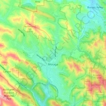
Nome: Mapa topográfico Moraga, altitude, relevo.
Local: Moraga, Contra Costa County, California, United States (37.80834 -122.15853 37.87572 -122.08783)
Altitude média: 224 m
Altitude mínima: 111 m
Altitude máxima: 431 m
Outros mapas topográficos
Clique em um mapa para visualizar sua topografia, sua altitude e seu relevo.
Contra Costa Centre
United States > California > Contra Costa County
Contra Costa Centre is an unincorporated community and census-designated place in Contra Costa County, California. Contra Costa Centre sits at an elevation of 92 feet (28 m). The 2010 United States census reported Contra Costa Centre's population was 5,364, while the 2020 census figure was 6,808. Contra Costa…
Altitude média: 36 m
Lafayette Reservoir
United States > California > Contra Costa County > Lafayette
Altitude média: 174 m
Saranap
United States > California > Contra Costa County
Saranap (until 1913, Dewing Park) is a residential census-designated place (CDP) within central Contra Costa County, California. Lying at an elevation of 180 feet (55 m), it is bounded on the south and east by portions of Walnut Creek (including the gated senior residential development Rossmoor) and on the…
Altitude média: 92 m
Crolona Heights
United States > California > Contra Costa County > Crockett > Crolona Heights
Altitude média: 61 m