
Mapa topográfico Grasmere
Clique no mapa para exibir a altitude.
Grasmere
The lake is 1680 yd (1540 m) long and 700 yd (640 m) wide, covering an area of 0.24 mi² (0.62 km²). It has a maximum depth of 70 ft (21m) and an elevation above sea level of 208 ft (62 m). The lake is both fed and drained by the River Rothay, which flows through the village before entering the lake, and then exits downstream into nearby Rydal Water, beyond which it continues into Windermere.
Sobre este mapa
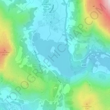
Nome: Mapa topográfico Grasmere, altitude, relevo.
Altitude média: 162 m
Altitude mínima: 54 m
Altitude máxima: 501 m