
Mapa topográfico Mountain City
Mapa interativo
Clique no mapa para exibir a altitude.
Sobre este mapa
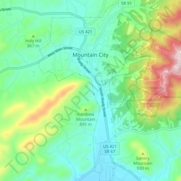
Nome: Mapa topográfico Mountain City, altitude, relevo.
Altitude média: 827 m
Altitude mínima: 691 m
Altitude máxima: 1.179 m
Mountain City is a town in and the county seat of Johnson County, Tennessee, United States. The population was 2,383 at the 2000 census and 2,531 at the 2010 census. It is the northeasternmost county seat in Tennessee. In addition, at an elevation of 2,418 feet (737 m), it has the distinction of being the highest incorporated city in the state.
Outros mapas topográficos
Clique em um mapa para visualizar sua topografia, sua altitude e seu relevo.
Catface Mountain
United States > Tennessee > Johnson County
Catface Mountain, Johnson County, East Tennessee, Tennessee, 28615, United States
Altitude média: 1.032 m
Cross Mountain
United States > Tennessee > Johnson County
Cross Mountain, Johnson County, Tennessee, United States
Altitude média: 1.054 m
Shouns
United States > Tennessee > Johnson County > Mountain City
Shouns, Mountain City, Johnson County, Tennessee, 37638, United States
Altitude média: 786 m
Sugar Creek
United States > Tennessee > Johnson County
Sugar Creek, Johnson County, Tennessee, 37680, United States
Altitude média: 890 m
Butler
United States > Tennessee > Johnson County
Butler, Johnson County, East Tennessee, Tennessee, United States
Altitude média: 671 m
Laurel Bloomery
United States > Tennessee > Johnson County
Laurel Bloomery, Johnson County, East Tennessee, Tennessee, 37680, United States
Altitude média: 806 m
Trade
United States > Tennessee > Johnson County
Trade, Johnson County, East Tennessee, Tennessee, 27691, United States
Altitude média: 1.035 m