
Faça uma doação
Mapa topográfico Geneva
Clique no mapa para exibir a altitude.
Faça uma doação
Geneva
The altitude of Geneva is 373.6 m (1,225.7 ft) and corresponds to the altitude of the largest of the Pierres du Niton, two large rocks emerging from the lake which date from the last ice age. This rock was chosen by General Guillaume Henri Dufour as the reference point for surveying in Switzerland. The second main river of Geneva is the Arve, which flows into the Rhône just west of the city centre. Mont Blanc can be seen from Geneva and is an hour's drive from the city.
Faça uma doação
Sobre este mapa
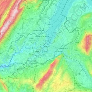
Nome: Mapa topográfico Geneva, altitude, relevo.
Local: Geneva, 1204, Switzerland (46.04176 5.98660 46.36176 6.30660)
Altitude média: 608 m
Altitude mínima: 326 m
Altitude máxima: 1.708 m
Faça uma doação
Outros mapas topográficos
Clique em um mapa para visualizar sua topografia, sua altitude e seu relevo.