
Mapa topográfico Brukom
Mapa interativo
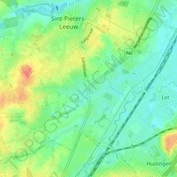
Clique no mapa para exibir a altitude.
Sobre este mapa
Nome: Mapa topográfico Brukom, altitude, relevo.
Altitude média: 39 m
Altitude mínima: 21 m
Altitude máxima: 72 m
Outros mapas topográficos
Clique em um mapa para visualizar sua topografia, sua altitude e seu relevo.
Oudenaken
België > Vlaams-Brabant > Halle-Vilvoorde > Sint-Pieters-Leeuw
Oudenaken, Sint-Pieters-Leeuw, Halle-Vilvoorde, Vlaams-Brabant, België
Altitude média: 41 m
Sint-Pieters-Leeuw
België > Vlaams-Brabant > Halle-Vilvoorde > Sint-Pieters-Leeuw
Sint-Pieters-Leeuw, Halle-Vilvoorde, Vlaams-Brabant, 1600, België
Altitude média: 42 m
Sobroek
België > Vlaams-Brabant > Halle-Vilvoorde > Sint-Pieters-Leeuw > Vlezenbeek
Sobroek, Vlezenbeek, Sint-Pieters-Leeuw, Halle-Vilvoorde, Vlaams-Brabant, Vlaanderen, 1602, België
Altitude média: 42 m
Vlezenbeek
België > Vlaams-Brabant > Halle-Vilvoorde > Sint-Pieters-Leeuw
Vlezenbeek, Sint-Pieters-Leeuw, Halle-Vilvoorde, Vlaams-Brabant, 1602, België
Altitude média: 47 m
Ruisbroek
België > Vlaams-Brabant > Halle-Vilvoorde > Sint-Pieters-Leeuw
Ruisbroek, Sint-Pieters-Leeuw, Halle-Vilvoorde, Vlaams-Brabant, 1601, België
Altitude média: 29 m