
Mapa topográfico Plano
Mapa interativo
Clique no mapa para exibir a altitude.
Sobre este mapa
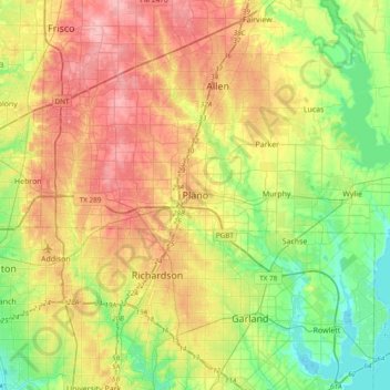
Nome: Mapa topográfico Plano, altitude, relevo.
Local: Plano, Collin County, Texas, 75074, United States (32.85368 -96.85251 33.17368 -96.53251)
Altitude média: 181 m
Altitude mínima: 131 m
Altitude máxima: 244 m
At first, Plano's population grew slowly, reaching 1,304 in 1900 and 3,695 in 1960. By 1970, Plano began to feel some of the boom its neighbors had experienced after World War II. A series of public works projects and a change in taxes that removed the farming community from the town helped increase the population. In 1970, the population reached 17,872, and by 1980, it had exploded to 72,000. Sewers, schools, and street development kept pace with this massive increase, largely because of Plano's flat topography, grid layout, and planning initiatives.
Outros mapas topográficos
Clique em um mapa para visualizar sua topografia, sua altitude e seu relevo.
White Rock Creek
United States > Texas > Collin County > Plano
White Rock Creek, Plano, Collin County, Texas, United States
Altitude média: 200 m
Chisholm Trail
United States > Texas > Collin County > Plano
Chisholm Trail, Plano, Collin County, Texas, United States
Altitude média: 210 m