
Faça uma doação
Mapa topográfico Dublin
Clique no mapa para exibir a altitude.
Faça uma doação
Dublin
Located on the Glaciated Allegheny Plateau, Dublin has a relatively flat topography. Nevertheless, there are numerous ravines surrounding the tributaries of the Scioto River, which make for steep cliffs in some areas. Elevations range from 780 feet (240 m) above sea level where the Scioto River leaves the city at Hayden Run Road, while the high point is 1,000 feet (300 m) at Glacier Ridge Metro Park.
Faça uma doação
Sobre este mapa
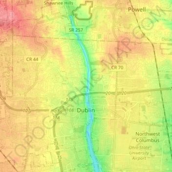
Nome: Mapa topográfico Dublin, altitude, relevo.
Altitude média: 275 m
Altitude mínima: 231 m
Altitude máxima: 311 m
Faça uma doação
Outros mapas topográficos
Clique em um mapa para visualizar sua topografia, sua altitude e seu relevo.
Columbus
United States > Ohio > Franklin County > Columbus
The confluence of the Scioto and Olentangy rivers is just north-west of Downtown Columbus. Several smaller tributaries course through the Columbus metropolitan area, including Alum Creek, Big Walnut Creek, and Darby Creek. Columbus is considered to have relatively flat topography thanks to a large glacier that…
Altitude média: 255 m
Faça uma doação
Faça uma doação