
Faça uma doação
Mapa topográfico Orinda
Clique no mapa para exibir a altitude.
Faça uma doação
Orinda
The area is characterized by a warm-summer Mediterranean climate (Köppen climate classification: Csb) with cool, rainy winters and warm, dry summers. Because Orinda is located in a hilly area, microclimates often dominate temperature differences in short distances. The Oakland Hills often block the cool foggy conditions that can be seen in Oakland and the inner Bay. In the summer, fog can spill over the Oakland hills, cooling off the area. Heatwaves from the inland areas can be felt much more in Orinda than in Oakland and the inner Bay during the summer. In the winter, Orinda often sees more precipitation than surrounding areas because of its higher elevation. Snowfall is rare but not unheard of. A dusting of snow may occur in any given year because of the elevation. During stable conditions in the winter, mornings can be cold and frosty in downtown and lower-lying areas, while the higher hills surrounding the area may be several degrees warmer.
Faça uma doação
Sobre este mapa
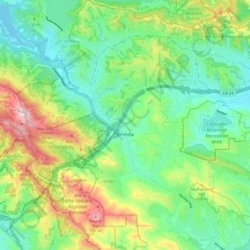
Nome: Mapa topográfico Orinda, altitude, relevo.
Altitude média: 246 m
Altitude mínima: 88 m
Altitude máxima: 570 m
Faça uma doação
Outros mapas topográficos
Clique em um mapa para visualizar sua topografia, sua altitude e seu relevo.
Contra Costa Centre
United States > California > Contra Costa County
Contra Costa Centre is an unincorporated community and census-designated place in Contra Costa County, California. Contra Costa Centre sits at an elevation of 92 feet (28 m). The 2010 United States census reported Contra Costa Centre's population was 5,364, while the 2020 census figure was 6,808. Contra Costa…
Altitude média: 36 m
Faça uma doação
Faça uma doação
Faça uma doação
Lafayette Reservoir
United States > California > Contra Costa County > Lafayette
Altitude média: 174 m
Saranap
United States > California > Contra Costa County
Saranap (until 1913, Dewing Park) is a residential census-designated place (CDP) within central Contra Costa County, California. Lying at an elevation of 180 feet (55 m), it is bounded on the south and east by portions of Walnut Creek (including the gated senior residential development Rossmoor) and on the…
Altitude média: 92 m
Faça uma doação
Faça uma doação
Faça uma doação
Faça uma doação
Crolona Heights
United States > California > Contra Costa County > Crockett > Crolona Heights
Altitude média: 61 m
Faça uma doação