
Obrigado por apoiar este site ❤️
Faça uma doação
Faça uma doação
Mapa topográfico Lorton
Clique no mapa para exibir a altitude.
Obrigado por apoiar este site ❤️
Faça uma doação
Faça uma doação
Lorton
According to the United States Census Bureau, the Lorton CDP has a total area of 5.4 square miles (13.9 km2), of which 5.3 square miles (13.7 km2) is land and 0.1 square miles (0.2 km2), or 1.39%, is water. The elevation ranges from sea level at the Prince William County line (the Occoquan River) to slightly over 200 feet (61 m) along Furnace Road at the CDP's western edge.
Obrigado por apoiar este site ❤️
Faça uma doação
Faça uma doação
Sobre este mapa
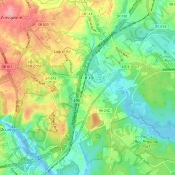
Nome: Mapa topográfico Lorton, altitude, relevo.
Local: Lorton, Fairfax County, Virginia, United States (38.66653 -77.24575 38.72283 -77.18004)
Altitude média: 37 m
Altitude mínima: -4 m
Altitude máxima: 91 m
Obrigado por apoiar este site ❤️
Faça uma doação
Faça uma doação