
Obrigado por apoiar este site ❤️
Faça uma doação
Faça uma doação
Mapa topográfico Fish Lake
Clique no mapa para exibir a altitude.
Obrigado por apoiar este site ❤️
Faça uma doação
Faça uma doação
Fish Lake
Fish Lake is a high alpine lake (elevation approximately 8,848 ft or 2,700 m) located in the Fishlake/ Southern Wasatch Plateau region of south-central Utah, United States. It lies within and is the namesake of the Fishlake National Forest.
Obrigado por apoiar este site ❤️
Faça uma doação
Faça uma doação
Sobre este mapa
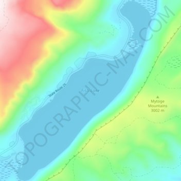
Nome: Mapa topográfico Fish Lake, altitude, relevo.
Local: Fish Lake, Sevier County, Utah, United States (38.51973 -111.73857 38.58301 -111.67746)
Altitude média: 2.886 m
Altitude mínima: 2.694 m
Altitude máxima: 3.438 m
Obrigado por apoiar este site ❤️
Faça uma doação
Faça uma doação
Outros mapas topográficos
Clique em um mapa para visualizar sua topografia, sua altitude e seu relevo.