
Obrigado por apoiar este site ❤️
Faça uma doação
Faça uma doação
Mapa topográfico Gascons
Clique no mapa para exibir a altitude.
Obrigado por apoiar este site ❤️
Faça uma doação
Faça uma doação
Sobre este mapa
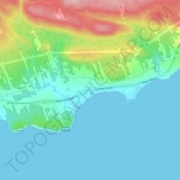
Nome: Mapa topográfico Gascons, altitude, relevo.
Altitude média: 49 m
Altitude mínima: -1 m
Altitude máxima: 183 m
Obrigado por apoiar este site ❤️
Faça uma doação
Faça uma doação
Outros mapas topográficos
Clique em um mapa para visualizar sua topografia, sua altitude e seu relevo.
Obrigado por apoiar este site ❤️
Faça uma doação
Faça uma doação
Chandler
Canada > Quebec > Le Rocher-Percé
The area was first settled in 1729, making it one of the oldest places on the Gaspé coast. It was known over time as Paboc, Pabo, Pabok, Pabeau, and Pas-bos. In 1815, the final spelling of Pabos was assigned in the Description topographique de la province du Bas Canada (Topographical Description of the…
Altitude média: 107 m