
Mapa topográfico Fortalecillas
Clique no mapa para exibir a altitude.
Sobre este mapa
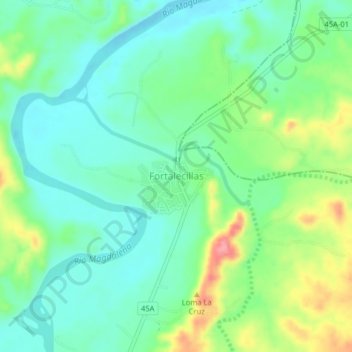
Nome: Mapa topográfico Fortalecillas, altitude, relevo.
Local: Fortalecillas, Norte, Huila, Colombia (3.01755 -75.27068 3.05755 -75.23068)
Altitude média: 434 m
Altitude mínima: 402 m
Altitude máxima: 504 m
Outros mapas topográficos
Clique em um mapa para visualizar sua topografia, sua altitude e seu relevo.
Altamira
Altamira is a small pueblo in the department Huila, with a population around 2,416. Its geographical coordinates are 2° 3' 46" North, 75° 47' 14" West. It is about an 8-hour bus trip south of Bogota. The largest city in Huila and its capital is Neiva, which is 89 miles north, with a population of about…
Altitude média: 1.032 m
La Plata
La Plata is a town and municipality in the Huila Department, Colombia, with a municipal population of 61,026 (2018 census) including the rural area, situated at an altitude of 1,050 m. It is located 122 km away from Neiva, 147 km from the city of Popayán and 210 km from the town of San Agustín.
Altitude média: 1.551 m
Yaguará
Yaguará (Spanish pronunciation: [ɟʝaɣwaˈɾa]) is a town and municipality in the Huila Department, Colombia. The urban centre is located at an elevation of 650 metres (2,130 ft) in the Magdalena River Valley and the Eastern Ranges of the Colombian Andes. The municipality borders Teruel and Palermo in the…
Altitude média: 842 m
Perímetro Urbano Neiva
Due to its location near the equator and its low altitude, the city has a hot annual average climate with daytime temperatures ranging from 88 to 95 degrees Fahrenheit. It is about 300 kilometers / 186.4 miles (about a five-hour drive) from the Colombian capital, Bogotá.
Altitude média: 469 m