
Faça uma doação
Mapa topográfico Atherton
Clique no mapa para exibir a altitude.
Faça uma doação
Sobre este mapa
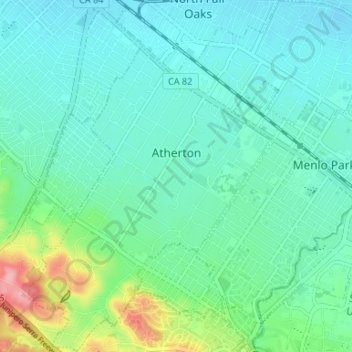
Nome: Mapa topográfico Atherton, altitude, relevo.
Altitude média: 30 m
Altitude mínima: 4 m
Altitude máxima: 124 m
Faça uma doação
Outros mapas topográficos
Clique em um mapa para visualizar sua topografia, sua altitude e seu relevo.
Faça uma doação
Faça uma doação
Red Morton Community Park
United States > California > San Mateo County > Redwood City
Altitude média: 18 m
Faça uma doação
Faça uma doação
Faça uma doação
Faça uma doação
Daly City
United States > California > San Mateo County > Daly City
Several golf courses are located within or straddle the border with San Francisco. The Olympic Club has hosted the USGA U.S. Open five times, most recently in 2012, and will host both the 2028 PGA Championship and the 2032 Ryder Cup. The private San Francisco Golf Club and Lake Merced Golf Club have part or…
Altitude média: 32 m
Half Moon Bay
United States > California > San Mateo County > Half Moon Bay > Half Moon Bay
Altitude média: 73 m
Faça uma doação
San Carlos
United States > California > San Mateo County > San Carlos > San Carlos
Altitude média: 47 m
Faça uma doação
Faça uma doação