
Faça uma doação
Mapa topográfico Boyardville
Clique no mapa para exibir a altitude.
Faça uma doação
Sobre este mapa
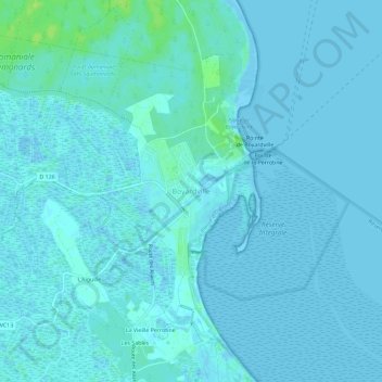
Nome: Mapa topográfico Boyardville, altitude, relevo.
Altitude média: 2 m
Altitude mínima: -2 m
Altitude máxima: 12 m
Faça uma doação
Outros mapas topográficos
Clique em um mapa para visualizar sua topografia, sua altitude e seu relevo.
Île de Ré
France > Nouvelle-Aquitaine > Charente-Maritime > Le Bois-Plage-en-Ré
Île de Ré (French pronunciation: [il də ʁe]; variously spelled Rhé or Rhéa; Poitevin: ile de Rét; English: Isle of Ré, /reɪ/ RAY) is an island off the Atlantic coast of France near La Rochelle, Charente-Maritime, on the northern side of the Pertuis d'Antioche strait. Its highest point has an…
Altitude média: 1 m
Faça uma doação
17220
France > Nouvelle-Aquitaine > Charente-Maritime > Saint-Médard-d'Aunis > Le Bois Léger
Altitude média: 19 m
Faça uma doação
Faça uma doação
Saintes
France > Nouvelle-Aquitaine > Charente-Maritime
Almost immediately west lies the neighbourhood of Saint-Eutrope, that has developed over the centuries around a rocky elevation bounded by two small valleys at right angles to the river. Dominated by the Saint-Eutrope basilica, it also contains the remains of a Clunian priory and several hillside houses.…
Altitude média: 36 m
Faça uma doação
Faça uma doação
Faça uma doação
Faça uma doação
Saintes
France > Nouvelle-Aquitaine > Charente-Maritime
Almost immediately west lies the neighbourhood of Saint-Eutrope, that has developed over the centuries around a rocky elevation bounded by two small valleys at right angles to the river. Dominated by the Saint-Eutrope basilica, it also contains the remains of a Clunian priory and several hillside houses.…
Altitude média: 36 m
17870
France > Nouvelle-Aquitaine > Charente-Maritime > Breuil-Magné > La Graulière
Altitude média: 10 m
Faça uma doação
Saintes
France > Nouvelle-Aquitaine > Charente-Maritime
Almost immediately west lies the neighbourhood of Saint-Eutrope, that has developed over the centuries around a rocky elevation bounded by two small valleys at right angles to the river. Dominated by the Saint-Eutrope basilica, it also contains the remains of a Clunian priory and several hillside houses.…
Altitude média: 36 m
Faça uma doação
Faça uma doação
Faça uma doação
Île de Ré
France > Nouvelle-Aquitaine > Charente-Maritime > Le Bois-Plage-en-Ré
Île de Ré (French pronunciation: [il də ʁe]; variously spelled Rhé or Rhéa; Poitevin: ile de Rét; English: Isle of Ré, /reɪ/ RAY) is an island off the Atlantic coast of France near La Rochelle, Charente-Maritime, on the northern side of the Pertuis d'Antioche strait. Its highest point has an elevation…
Altitude média: 1 m
Faça uma doação
Communauté de communes Aunis Atlantique
France > Nouvelle-Aquitaine > Charente-Maritime
Altitude média: 11 m
Faça uma doação
Faça uma doação
Faça uma doação
17110
France > Nouvelle-Aquitaine > Charente-Maritime > Saint-Georges-de-Didonne > Les Moulins
Altitude média: 11 m
Saint-Hilaire-de-Villefranche
France > Nouvelle-Aquitaine > Charente-Maritime > Saint-Hilaire-de-Villefranche
Altitude média: 55 m
Faça uma doação
Faça uma doação
Saint-Palais-de-Négrignac
France > Nouvelle-Aquitaine > Charente-Maritime > Saint-Palais-de-Négrignac
Altitude média: 97 m
Faça uma doação