
Mapa topográfico Berner Alpen
Mapa interativo
Clique no mapa para exibir a altitude.
Sobre este mapa
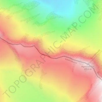
Nome: Mapa topográfico Berner Alpen, altitude, relevo.
Altitude média: 3.306 m
Altitude mínima: 2.604 m
Altitude máxima: 3.911 m
Outros mapas topográficos
Clique em um mapa para visualizar sua topografia, sua altitude e seu relevo.
Wetterhorn
Switzerland > Bern > Grindelwald
Wetterhorn, Grindelwald, Verwaltungskreis Interlaken-Oberhasli, Verwaltungsregion Oberland, Bern, Switzerland
Altitude média: 2.864 m