
Obrigado por apoiar este site ❤️
Faça uma doação
Faça uma doação
Mapa topográfico Treasure Island
Clique no mapa para exibir a altitude.
Obrigado por apoiar este site ❤️
Faça uma doação
Faça uma doação
Treasure Island
With an elevation of only three feet, the Great Gale of 1848 carved out John's Pass on the island's north end and split off two smaller islands, called the Isle of Palms and Isle of Capri.
Obrigado por apoiar este site ❤️
Faça uma doação
Faça uma doação
Sobre este mapa
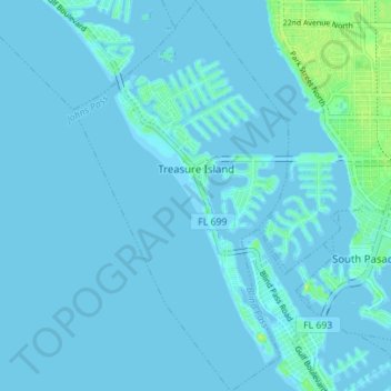
Nome: Mapa topográfico Treasure Island, altitude, relevo.
Local: Treasure Island, Pinellas County, Florida, United States (27.73403 -82.79093 27.79570 -82.75252)
Altitude média: 2 m
Altitude mínima: -2 m
Altitude máxima: 14 m
Obrigado por apoiar este site ❤️
Faça uma doação
Faça uma doação
Outros mapas topográficos
Clique em um mapa para visualizar sua topografia, sua altitude e seu relevo.
Obrigado por apoiar este site ❤️
Faça uma doação
Faça uma doação
Obrigado por apoiar este site ❤️
Faça uma doação
Faça uma doação
Obrigado por apoiar este site ❤️
Faça uma doação
Faça uma doação