Geolocalizar

Mapa topográfico Castle Park

Mapa interativo

Clique no mapa para exibir a altitude.

Sobre este mapa

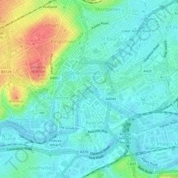
Nome: Mapa topográfico Castle Park, altitude, relevo.

Local: Castle Park, Old City, Finzels Reach, Bristol, City of Bristol, South West England, England, BS1 2AN, United Kingdom (51.45387 -2.59196 51.45666 -2.58517)

Altitude média: 26 m

Altitude mínima: 6 m

Altitude máxima: 86 m

The main objection to this plan came from the independent traders who did not wish to relocate because they felt that the proposed new shopping area was 'off the beaten track'. This objection was not unreasonable, as in its pre-war topography Bristol had a long shopping axis that started at Stapleton Road to the east, passed through Old Market into Castle Street, Wine Street, and the City Markets, and then via The Centre and Park Street to Queens Road and Whiteladies Road. Moving the central shopping area would break this axis. There was also concern about the serious negative social and economic impacts of 'sterilising' such a large area in the centre of the city. However, when the Bristol Retail Traders Federation, representing the small traders, produced a poll showing that 13,000 people wished to retain the shopping centre on its current site whereas only 400 preferred to see it moved, the local Labour party dismissed the poll describing it as 'undemocratic' and comparing the Federation's methods to those of Hitler.

Outros mapas topográficos

Clique em um mapa para visualizar sua topografia, sua altitude e seu relevo.

Whitchurch Park Ward

United Kingdom > England > City of Bristol > Bristol

Whitchurch Park Ward, Bristol, City of Bristol, West of England, England, United Kingdom

Altitude média: 91 m

Rownham Plantation

United Kingdom > England > City of Bristol > Bristol

Rownham Plantation, Bower Ashton, Hotwells, Bristol, City of Bristol, West of England, England, United Kingdom

Altitude média: 58 m

Penpole Wood

United Kingdom > England > City of Bristol > Bristol

Penpole Wood, Shirehampton, Bristol, City of Bristol, West of England, England, BS11 0UR, United Kingdom

Altitude média: 24 m

St Andrew's Park

United Kingdom > England > City of Bristol > Bristol

St Andrew's Park, St Andrew's, Bristol, City of Bristol, West of England, England, United Kingdom

Altitude média: 47 m

Clifton Down

United Kingdom > England > City of Bristol > Bristol

Clifton Down, Sneyd Park, Bristol, City of Bristol, West of England, England, BS8 3LT, United Kingdom

Altitude média: 73 m

Leigh Woods

United Kingdom > England > City of Bristol > Bristol

Leigh Woods, Stoke Park Road, Stoke Bishop, Bristol, City of Bristol, West of England, England, BS9 1JE, United Kingdom

Altitude média: 78 m

Moorgrove Wood

United Kingdom > England > City of Bristol > Bristol > Blaise Hamlet

Moorgrove Wood, Blaise Hamlet, Bristol, City of Bristol, West of England, England, United Kingdom

Altitude média: 40 m

Eastville Park

United Kingdom > England > City of Bristol > Bristol

Eastville Park, Eastville, Bristol, City of Bristol, West of England, England, BS5 6PX, United Kingdom

Altitude média: 47 m

Bristol Port Railway

United Kingdom > England > City of Bristol > Bristol

Bristol Port Railway, Bridge Valley Road, Clifton, Bristol, City of Bristol, South West England, England, BS8, United Kingdom

Altitude média: 68 m

Floating Harbour

United Kingdom > England > City of Bristol > Bristol

Floating Harbour, Spike Island, Bristol, City of Bristol, West of England, England, United Kingdom

Altitude média: 22 m