
Mapa topográfico Cockburn Range
Clique no mapa para exibir a altitude.
Sobre este mapa
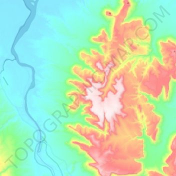
Nome: Mapa topográfico Cockburn Range, altitude, relevo.
Local: Cockburn Range, Western Australia, Australia (-15.83805 127.91481 -15.63519 128.02144)
Altitude média: 188 m
Altitude mínima: 0 m
Altitude máxima: 587 m
Outros mapas topográficos
Clique em um mapa para visualizar sua topografia, sua altitude e seu relevo.
Gibson Desert
The Gibson Desert is located between the saline Kumpupintil Lake and Lake Macdonald along the Tropic of Capricorn, south of the Great Sandy Desert, east of the Little Sandy Desert, and north of the Great Victoria Desert. The altitude rises to just above 500 metres (1,600 ft) in places. As noted by early…
Altitude média: 464 m
Tom Price
Tom Price is the closest town to Karijini National Park and is serviced by the nearby Paraburdoo Airport. Due to its elevation (747 m (2,451 ft)), temperatures are lowered and rainfall is intensified, resulting in the town possessing a subtropical semi-arid climate (Köppen: BSh). Summers are very hot with…
Altitude média: 791 m
Carnarvon
From 1964 to 1965, 12 sounding rockets were launched from Carnarvon to a maximum altitude of 120 km (75 mi).
Altitude média: 4 m
Rockingham
Australia > Western Australia > Rockingham
Rockingham is topographically flat, has sandy soils and coastal vegetation. It has a northern aspect to Cockburn Sound, from Rockingham Beach and Palm Beach.
Altitude média: 4 m