
Mapa topográfico Gila Wilderness
Mapa interativo
Clique no mapa para exibir a altitude.
Sobre este mapa
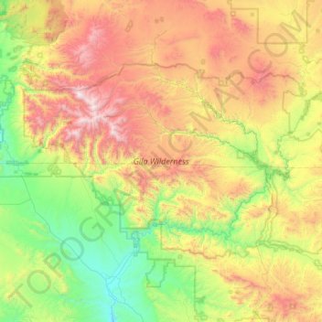
Nome: Mapa topográfico Gila Wilderness, altitude, relevo.
Local: Gila Wilderness, Catron County, New Mexico, United States (33.00793 -108.81918 33.41853 -108.00968)
Altitude média: 2.085 m
Altitude mínima: 1.340 m
Altitude máxima: 3.327 m
The Gila Wilderness is located in southwest New Mexico, north of Silver City and east of Reserve. It contains the West Fork, Middle Fork and much of the East Fork of the Gila River; riverside elevations of around 4,850 feet (1,480 m) are the lowest in the wilderness. The Mogollon Mountains traverse an arc across the wilderness. The tallest peak within this range, Whitewater Baldy at 10,895 ft (3,321 m), is in the northwest part of the wilderness along with several other summits more than 10,000 ft (3,048 m) high. At the northeast corner is prominent Black Mountain rising to 9,287 ft (2,831 m). The Gila Cliff Dwellings National Monument is adjacent to the wilderness.
Outros mapas topográficos
Clique em um mapa para visualizar sua topografia, sua altitude e seu relevo.
Prairie Lake
United States > New Mexico > Catron County
Prairie Lake, Catron County, New Mexico, United States
Altitude média: 2.342 m
San Francisco
United States > New Mexico > Catron County
San Francisco, Catron County, New Mexico, United States
Altitude média: 2.440 m
Quemado
United States > New Mexico > Catron County
Quemado, Catron County, New Mexico, United States
Altitude média: 2.113 m
Alma
United States > New Mexico > Catron County
Alma, Catron County, New Mexico, United States
Altitude média: 1.535 m
Capital Dome
United States > New Mexico > Catron County
Capital Dome, Catron County, New Mexico, United States
Altitude média: 2.459 m
Cruzville
United States > New Mexico > Catron County
Cruzville, Catron County, New Mexico, United States
Altitude média: 1.975 m
Reserve
United States > New Mexico > Catron County
Reserve, Catron County, New Mexico, United States
Altitude média: 1.780 m
Datil
United States > New Mexico > Catron County
Datil, Catron County, New Mexico, United States
Altitude média: 2.279 m
Pie Town
United States > New Mexico > Catron County
Pie Town, Catron County, New Mexico, 87827, United States
Altitude média: 2.352 m
San Francisco Mountains
United States > New Mexico > Catron County
San Francisco Mountains, Catron County, New Mexico, United States
Altitude média: 2.541 m