
Mapa topográfico Olivos
Mapa interativo
Clique no mapa para exibir a altitude.
Sobre este mapa
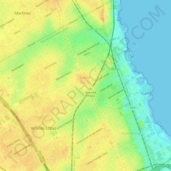
Nome: Mapa topográfico Olivos, altitude, relevo.
Altitude média: 17 m
Altitude mínima: -2 m
Altitude máxima: 31 m
Olivos is located on the western bank of the Río de la Plata, the world's widest river. The river is approximately 50 km (31 mi) wide at Olivos, and as such, Uruguay is not visible from ground level. However, Olivos (and this entire region of the Rio) do not have sandy beaches; the shoreline is relatively rocky. Comparable shorelines include those of the Great Lakes in North America. The city's topography is relatively flat. However, there are some ridges by the river towards the north, in the La Lucila neighbourhood.
Outros mapas topográficos
Clique em um mapa para visualizar sua topografia, sua altitude e seu relevo.
Munro
Argentina > Buenos Aires > Vicente López
Munro, Vicente López, Partido de Vicente López, Buenos Aires, Argentina
Altitude média: 26 m
Vicente López
Argentina > Buenos Aires > Vicente López
Vicente López, Partido de Vicente López, Buenos Aires, Argentina
Altitude média: 20 m