
Obrigado por apoiar este site ❤️
Faça uma doação
Faça uma doação
Mapa topográfico District 9
Clique no mapa para exibir a altitude.
Obrigado por apoiar este site ❤️
Faça uma doação
Faça uma doação
Sobre este mapa
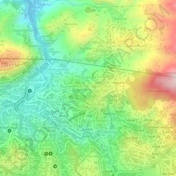
Nome: Mapa topográfico District 9, altitude, relevo.
Altitude média: 1.455 m
Altitude mínima: 1.327 m
Altitude máxima: 1.629 m
Obrigado por apoiar este site ❤️
Faça uma doação
Faça uma doação
Outros mapas topográficos
Clique em um mapa para visualizar sua topografia, sua altitude e seu relevo.
Tuba
Tuba's topography is generally characterized by irregular rugged terrain and steep slopes with several mountain peaks rising from the table land itself. Mount Santo Tomas, the highest peak in the municipality soars to 2,252 metres (7,388 ft) above sea level.
Altitude média: 1.256 m