
Mapa topográfico Aberdeenshire
Mapa interativo
Clique no mapa para exibir a altitude.
Sobre este mapa
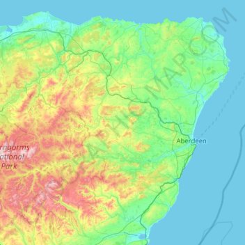
Nome: Mapa topográfico Aberdeenshire, altitude, relevo.
Local: Aberdeenshire, Schotland, VK (56.74718 -3.80170 57.70179 -1.76440)
Altitude média: 199 m
Altitude mínima: 0 m
Altitude máxima: 1.296 m
Outros mapas topográficos
Clique em um mapa para visualizar sua topografia, sua altitude e seu relevo.
Old Polmont
VK > Schotland > Old Polmont
Old Polmont, Falkirk, Schotland, FK2 0XZ, VK
Altitude média: 37 m
Greenbraehead
VK > Schotland > Greenbraehead
Greenbraehead, Scottish Borders, Schotland, TD9 9SW, VK
Altitude média: 187 m
Loch Lubnaig
VK > Schotland > Ardchullarie More
Loch Lubnaig, A84, Ardchullarie More, Stirling, Schotland, FK17 8HF, VK
Altitude média: 382 m
Inverasdale
VK > Schotland > Inverasdale
Inverasdale, Highland, Schotland, IV22 2LW, VK
Altitude média: 54 m
Loch Lomond
Loch Lomond, A82, Tom Na Glas, Inverbeg, Argyll and Bute, Schotland, G83 8PD, VK
Altitude média: 240 m
Fort Augustus
VK > Schotland > Fort Augustus
Fort Augustus, Highland, Schotland, PH32 4AY, VK
Altitude média: 115 m