
Mapa topográfico Stupava
Mapa interativo
Clique no mapa para exibir a altitude.
Sobre este mapa
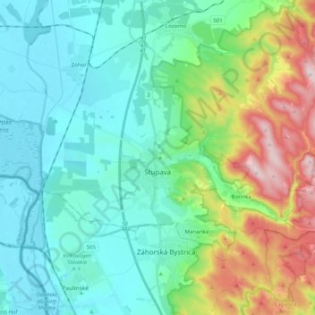
Nome: Mapa topográfico Stupava, altitude, relevo.
Altitude média: 237 m
Altitude mínima: 137 m
Altitude máxima: 540 m
The town is located in the Záhorie lowland, under the Little Carpathians, around 15 km (9 mi) north of Bratislava at an altitude of 182 metres. It has 15, 095 inhabitants as of 2021 and has a land area of 67.17 km2 (26 sq mi). Apart from the core part of the city, Mást (German: Maaßt, Hungarian: Mászt), located just south of the core part of the city, is another part of Stupava. It has been initially a separate village with ethnic Croatian majority, which was formally annexed by Stupava in 1953.
Outros mapas topográficos
Clique em um mapa para visualizar sua topografia, sua altitude e seu relevo.
Marianka
Slovakia > Region of Bratislava > District of Malacky
Marianka, District of Malacky, Region of Bratislava, 900 33, Slovakia
Altitude média: 249 m
Kuchyňa
Slovakia > Region of Bratislava > District of Malacky
Kuchyňa, District of Malacky, Region of Bratislava, 900 52, Slovakia
Altitude média: 319 m
Malacky
Slovakia > Region of Bratislava > District of Malacky
Malacky, District of Malacky, Region of Bratislava, Slovakia
Altitude média: 168 m
Borinka
Slovakia > Region of Bratislava > District of Malacky > Borinka
Borinka, District of Malacky, Region of Bratislava, Slovakia
Altitude média: 304 m