
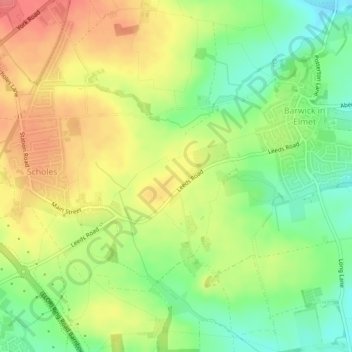
Mapa topográfico Limekiln
Mapa interativo
Clique no mapa para exibir a altitude.
Sobre este mapa
Nome: Mapa topográfico Limekiln, altitude, relevo.
Altitude média: 89 m
Altitude mínima: 55 m
Altitude máxima: 122 m
Outros mapas topográficos
Clique em um mapa para visualizar sua topografia, sua altitude e seu relevo.
Churwell
United Kingdom > England > Leeds
Churwell, Leeds, West Yorkshire, England, LS27 7QR, United Kingdom
Altitude média: 96 m
Ledston
United Kingdom > England > Leeds
Ledston, Leeds, West Yorkshire, England, United Kingdom
Altitude média: 45 m
East Rigton
United Kingdom > England > Leeds
East Rigton, Leeds, West Yorkshire, England, LS17 9AZ, United Kingdom
Altitude média: 72 m
Bramhope
United Kingdom > England > Leeds > Bramhope
Bramhope, Leeds, West Yorkshire, England, United Kingdom
Altitude média: 143 m
Boston Spa
United Kingdom > England > Leeds > Wetherby
Boston Spa, Wetherby, Leeds, West Yorkshire, England, United Kingdom
Altitude média: 34 m
Kippax
United Kingdom > England > Leeds > Great Preston
Kippax, Great Preston, Leeds, West Yorkshire, England, United Kingdom
Altitude média: 56 m
Yeadon
United Kingdom > England > Leeds
Yeadon, Leeds, West Yorkshire, England, LS19 7RS, United Kingdom
Altitude média: 142 m
Guiseley
United Kingdom > England > Leeds
Guiseley, Leeds, West Yorkshire, England, LS20 9FN, United Kingdom
Altitude média: 140 m