
Faça uma doação
Mapa topográfico Plains Mill
Clique no mapa para exibir a altitude.
Faça uma doação
Sobre este mapa
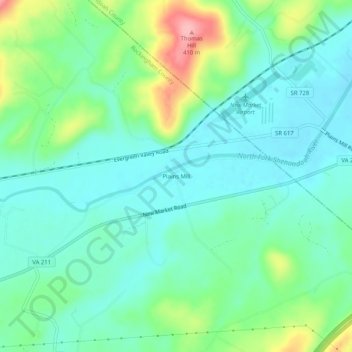
Nome: Mapa topográfico Plains Mill, altitude, relevo.
Local: Plains Mill, Rockingham County, Virginia, United States (38.62678 -78.73919 38.66678 -78.69919)
Altitude média: 316 m
Altitude mínima: 282 m
Altitude máxima: 409 m
Faça uma doação
Outros mapas topográficos
Clique em um mapa para visualizar sua topografia, sua altitude e seu relevo.
Faça uma doação
Harrisonburg/Warm Springs Turnpike Park
United States > Virginia > Rockingham County > Bridgewater
Altitude média: 378 m
Faça uma doação
Faça uma doação
Bridgewater
United States > Virginia > Rockingham County
According to the United States Census Bureau, the town has a total area of 2.52 sq mi (6.5 km2), nearly all of it being land. Most of the town is located within a bend of the North River. Floods have wrecked the town occasionally. The northern areas are partly shielded from flooding with an Army Corps of…
Altitude média: 380 m