Geolocalizar

Mapa topográfico Mount Trickett

Clique no mapa para exibir a altitude.

Sobre este mapa

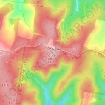
Nome: Mapa topográfico Mount Trickett, altitude, relevo.

Local: Mount Trickett, Oberon Council, New South Wales, Australia (-33.83297 149.98354 -33.83287 149.98364)

Altitude média: 1.284 m

Altitude mínima: 1.155 m

Altitude máxima: 1.360 m

Outros mapas topográficos

Clique em um mapa para visualizar sua topografia, sua altitude e seu relevo.

Sydney

Australia > New South Wales

Sydney's topography is characterized by a diverse landscape that seamlessly blends coastal features with inland plateaus. The city is divided into two primary regions: the relatively flat Cumberland Plain to the south and west of Sydney Harbour, and the elevated Hornsby Plateau to the north. The Cumberland…

Altitude média: 53 m

Newcastle

Australia > New South Wales

Altitude média: 5 m

Goulburn

Australia > New South Wales

Owing to its elevation, Goulburn has an oceanic climate (Cfb) with warm summers and cool winters; with a high diurnal range. Its climate is variable much of the year, though generally dry with maximum temperatures ranging from 11.8 °C (53.2 °F) in July to 28.3 °C (82.9 °F) in January. Rainfall is…

Altitude média: 666 m

Glebe

Australia > New South Wales > Sydney

Altitude média: 18 m

Bocoble

Australia > New South Wales

Altitude média: 832 m

Bowral

Australia > New South Wales

Altitude média: 690 m

Illawarra

Australia > New South Wales

Altitude média: 234 m

Chatswood

Australia > New South Wales

Altitude média: 81 m

Duns Creek

Australia > New South Wales

The suburb is bordered in the west by the Paterson River where the land is only approximately 3 m (10 ft) above mean sea level (AMSL) and undulating with a few small hills. This continues to the eastern extent of the suburb where the a range of hills begins, just before the border with Glen Oak. Heading north…

Altitude média: 96 m

Stockrington

Australia > New South Wales

Altitude média: 85 m

Scotts Head

Australia > New South Wales

Altitude média: 5 m

Mullumbimby

Australia > New South Wales

Altitude média: 29 m

Blackheath

Australia > New South Wales

Blackheath (postcode: 2785) is an Australian town located near the highest point of the Blue Mountains, between Katoomba and Mount Victoria in New South Wales. The town's altitude is about 1,065 metres (3,494 ft) AHD  and it is located about 120 kilometres (75 mi) west north-west of Sydney, 11 kilometres…

Altitude média: 893 m

Camden Council

Australia > New South Wales

Altitude média: 90 m

Mudgee

Australia > New South Wales

Altitude média: 535 m

Uki

Australia > New South Wales

Altitude média: 84 m

Hill Top

Australia > New South Wales

Altitude média: 543 m

Braidwood

Australia > New South Wales

Altitude média: 674 m

Orange

Australia > New South Wales

Orange is a city in the Central Tablelands region of New South Wales, Australia. It is 254 km (158 mi) west of the state capital, Sydney [206 km (128 mi) on a great circle], at an altitude of 862 metres (2,828 ft). Orange had an estimated urban population of 40,493 as of June 2018 making the city a significant…

Altitude média: 852 m

Khancoban

Australia > New South Wales

Altitude média: 642 m

Long Beach

Australia > New South Wales

Altitude média: 31 m

Holbrook

Australia > New South Wales

Altitude média: 334 m

Blue Mountains

Australia > New South Wales

A sandstone plateau dominated by a landscape of endless eucalyptus forests, the Blue Mountains are located at the top of a 470-million-year-old quartzite. In the Permian period, a shallow sea covered the region, when rivers brought shales, siltstones and mudstones. Then during the Mesozoic period, rivers…

Altitude média: 566 m

Tenterfield

Australia > New South Wales

Altitude média: 891 m

Baw Baw

Australia > New South Wales

Altitude média: 699 m

Maitland

Australia > New South Wales

Altitude média: 11 m

King Creek

Australia > New South Wales

Altitude média: 35 m

Crabbes Creek

Australia > New South Wales

Altitude média: 48 m

Lismore Heights

Australia > New South Wales

Altitude média: 48 m

Penrith

Australia > New South Wales > Sydney > Penrith

Penrith is a city in New South Wales, Australia, located in Greater Western Sydney, 55 kilometres (31 mi) west of the Sydney central business district on the banks of the Nepean River, on the outskirts of the Cumberland Plain. Its elevation is 32 metres (105 ft).

Altitude média: 34 m

Byron Bay

Australia > New South Wales

Byron Bay, located in northeastern New South Wales, Australia, is characterized by diverse topography shaped by its geological history. The town is part of the erosion caldera of the ancient Tweed Volcano, which erupted approximately 23 million years ago, resulting in the rich volcanic soils that define the…

Altitude média: 7 m

Glen Innes

Australia > New South Wales

Altitude média: 1.083 m

St Ives

Australia > New South Wales

Altitude média: 125 m

Manly

Australia > New South Wales

Altitude média: 17 m

Mount Colah

Australia > New South Wales > Sydney

Mount Colah is 5 km north of Hornsby, the nearest major town centre. It is one of the most northerly suburbs of Sydney and is where the "Welcome to Sydney" sign is located. Mount Colah is the second highest suburb in Sydney by elevation. Considered one of Sydney's leafier suburbs, streets are clustered around…

Altitude média: 152 m

Tyalgum

Australia > New South Wales

Altitude média: 161 m

Goonellabah

Australia > New South Wales

Altitude média: 86 m

North Richmond

Australia > New South Wales > Sydney

Altitude média: 67 m

Lismore

Australia > New South Wales

Altitude média: 23 m

Batlow

Australia > New South Wales

Altitude média: 803 m

Tilba Tilba

Australia > New South Wales

Altitude média: 84 m

Ganmain

Australia > New South Wales

Altitude média: 201 m

New Brighton

Australia > New South Wales

Altitude média: 5 m

Broke

Australia > New South Wales

Altitude média: 220 m

Upper Orara

Australia > New South Wales

Altitude média: 271 m

Moruya

Australia > New South Wales

Altitude média: 37 m

Caniaba

Australia > New South Wales

Altitude média: 47 m

Olney

Australia > New South Wales

Altitude média: 226 m

Capertee

Australia > New South Wales

Altitude média: 757 m

Barrington Tops

Australia > New South Wales

Altitude média: 1.107 m

Carlingford

Australia > New South Wales > Sydney

Altitude média: 98 m

Mosman

Australia > New South Wales > Sydney

Altitude média: 29 m

Wahroonga

Australia > New South Wales

Altitude média: 159 m

Eastwood

Australia > New South Wales > Sydney

Altitude média: 80 m

Mittagong

Australia > New South Wales

Altitude média: 672 m

Casino

Australia > New South Wales

Altitude média: 32 m

Little Hartley

Australia > New South Wales

Altitude média: 790 m

Blaxland

Australia > New South Wales

Altitude média: 214 m

Terrey Hills

Australia > New South Wales > Sydney

Owing to its elevation and close proximity to the ocean, as well as its extensive tree canopy cover, the weather station at Terrey Hills records the mildest temperatures of any weather station in the Greater Sydney region. Under Köppen's scheme, the suburb has a borderline humid subtropical (Cfa) and oceanic…

Altitude média: 146 m

Berowra Heights

Australia > New South Wales

Altitude média: 125 m

Ashfield

Australia > New South Wales > Sydney

Altitude média: 26 m

Taree

Australia > New South Wales

Altitude média: 17 m

Turramurra

Australia > New South Wales > Sydney

Altitude média: 143 m

Perisher Valley

Australia > New South Wales

Altitude média: 1.704 m

Dulwich Hill

Australia > New South Wales > Sydney

Altitude média: 27 m

Epping

Australia > New South Wales > Sydney

Altitude média: 96 m

Wauchope

Australia > New South Wales

Altitude média: 32 m

Rooty Hill

Australia > New South Wales > Sydney

Altitude média: 52 m

Caringbah

Australia > New South Wales > Sydney

Altitude média: 17 m

Bundeena

Australia > New South Wales > Sydney

Altitude média: 20 m

Wentworth Falls

Australia > New South Wales > Sydney

Wentworth Falls (postcode: 2782) is a town in the Blue Mountains region of New South Wales, situated approximately 100 kilometres (62 mi) west of the Sydney central business district, and about 8 kilometres (5.0 mi) east of Katoomba, Australia on the Great Western Highway, with a Wentworth Falls railway…

Altitude média: 708 m

Terranora

Australia > New South Wales

Altitude média: 34 m

Hazelbrook

Australia > New South Wales

Hazelbrook is a town in New South Wales, Australia (Elevation: 675 metres) It is located 91 kilometres west of Sydney and 16 kilometres east of Katoomba in the Blue Mountains on the Great Western Highway.

Altitude média: 610 m

Bingara

Australia > New South Wales

Altitude média: 394 m

Sydney

Australia > New South Wales > Sydney

Altitude média: 23 m

Macquarie River

Australia > New South Wales

Altitude média: 139 m