
Mapa topográfico Thomasburg
Mapa interativo
Clique no mapa para exibir a altitude.
Sobre este mapa
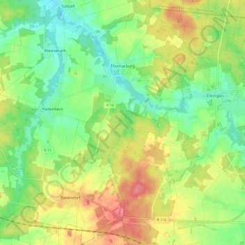
Nome: Mapa topográfico Thomasburg, altitude, relevo.
Altitude média: 50 m
Altitude mínima: 18 m
Altitude máxima: 91 m
Outros mapas topográficos
Clique em um mapa para visualizar sua topografia, sua altitude e seu relevo.
Reinstorf
Germany > Lower Saxony > Lüneburg
Reinstorf, Samtgemeinde Ostheide, Lüneburg, Lower Saxony, 21400, Germany
Altitude média: 53 m