
Mapa topográfico Stonewall
Mapa interativo
Clique no mapa para exibir a altitude.
Stonewall
When the last ice age retreated, as well as the prairies, escarpments such as Riding Mountain were left behind. In addition to these, smaller elevations were left behind such as Stony Mountain and Stonewall. It is believed that these escarpments were used as look-outs by early hunters approximately 4,000 to 5,000 years ago. These formations were later used as buffalo jumps by the indigenous populations.
Sobre este mapa
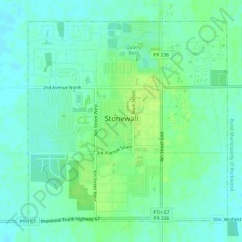
Nome: Mapa topográfico Stonewall, altitude, relevo.
Local: Stonewall, Division No. 14, Manitoba, R0C 2Z0, Canada (50.12275 -97.34503 50.14507 -97.31026)
Altitude média: 251 m
Altitude mínima: 245 m
Altitude máxima: 259 m
Outros mapas topográficos
Clique em um mapa para visualizar sua topografia, sua altitude e seu relevo.
Sunset Beach
Canada > Manitoba > Division No. 13 > Rural Municipality of St. Clements
Altitude média: 223 m
Turtle Mountain Provincial Park
Canada > Manitoba > Municipality of Boissevain-Morton
Altitude média: 662 m
Silverton
Canada > Manitoba > Division No. 16 > Rural Municipality of Riding Mountain West
Altitude média: 575 m
Ile des Chenes
Canada > Manitoba > Division No. 2 > Rural Municipality of Ritchot
Altitude média: 236 m
Lenore
Canada > Manitoba > Division No. 6 > Rural Municipality of Wallace – Woodworth
Altitude média: 460 m
Oak Lake Beach
Canada > Manitoba > Division No. 6 > Rural Municipality of Sifton
Altitude média: 429 m
Butler
Canada > Manitoba > Division No. 6 > Rural Municipality of Wallace – Woodworth
Altitude média: 524 m
Winnipeg
Canada > Manitoba > Winnipeg > Winnipeg
Winnipeg lies at the bottom of the Red River Valley, a flood plain with an extremely flat topography. It is on the eastern edge of the Canadian Prairies in Western Canada and is known as the "Gateway to the West". Winnipeg is bordered by tallgrass prairie to the west and south and the aspen parkland to the…
Altitude média: 236 m