
Mapa topográfico Atauro
Mapa interativo
Clique no mapa para exibir a altitude.
Sobre este mapa
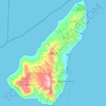
Nome: Mapa topográfico Atauro, altitude, relevo.
Local: Atauro, East Timor (-8.30883 125.50112 -8.12690 125.64390)
Altitude média: 108 m
Altitude mínima: 0 m
Altitude máxima: 967 m
The landscape of the island is a result of the erosion of uplifted, originally submarine, volcanos from the Neogene period creating narrow, dissected ridges and steep slopes. Up to an elevation of about 600 m there are also extensive areas of uplifted coralline limestone. The climate is distinctly seasonal, with wet and dry seasons. The island has suffered from extensive clearing of its native vegetation for swidden agriculture. The upper levels of Mount Manucoco (above 700 m) still carry patches of tropical semi-evergreen mountain forest in sheltered valleys, covering about 40 km2. Lower down there are remnants of drier forest and Eucalyptus alba dominated savanna woodlands, especially on limestone outcrops, with agricultural land in the vicinity of villages. The island has a fringing reef 30–150 m in width; it generally lacks freshwater wetlands, estuaries and mangroves. In 2016 a Conservation International team found more species of reef fish per site in the waters surrounding the island than anywhere else in the world.
Outros mapas topográficos
Clique em um mapa para visualizar sua topografia, sua altitude e seu relevo.
Margem de rio
East Timor > Viqueque > Viqueque
Margem de rio, Viqueque, East Timor
Altitude média: 252 m