
Mapa topográfico Reichmannsdorf
Mapa interativo
Clique no mapa para exibir a altitude.
Sobre este mapa
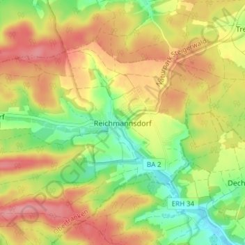
Nome: Mapa topográfico Reichmannsdorf, altitude, relevo.
Altitude média: 338 m
Altitude mínima: 287 m
Altitude máxima: 385 m
Outros mapas topográficos
Clique em um mapa para visualizar sua topografia, sua altitude e seu relevo.
Wüstenbuch
Deutschland > Bayern > Landkreis Bamberg > Schlüsselfeld
Wüstenbuch, Schlüsselfeld, Landkreis Bamberg, Bayern, 96132, Deutschland
Altitude média: 380 m
Elsendorf
Deutschland > Bayern > Landkreis Bamberg > Schlüsselfeld
Elsendorf, Schlüsselfeld, Landkreis Bamberg, Bayern, 96132, Deutschland
Altitude média: 323 m
Rambach
Deutschland > Bayern > Landkreis Bamberg > Schlüsselfeld
Rambach, Schlüsselfeld, Landkreis Bamberg, Bayern, 96132, Deutschland
Altitude média: 338 m
Güntersdorf
Deutschland > Bayern > Landkreis Bamberg > Schlüsselfeld > Lach
Güntersdorf, Lach, Schlüsselfeld, Landkreis Bamberg, Bayern, 96132, Deutschland
Altitude média: 318 m
Obermelsendorf
Deutschland > Bayern > Landkreis Bamberg > Schlüsselfeld > Obermelsendorf
Obermelsendorf, Schlüsselfeld, Landkreis Bamberg, Bayern, 96132, Deutschland
Altitude média: 355 m