
Mapa topográfico Chandigarh
Mapa interativo
Clique no mapa para exibir a altitude.
Chandigarh
Chandigarh is located near the foothills of the Sivalik range of the Himalayas in northwest India. It covers an area of approximately 114 km2. It borders the states of Haryana and Punjab. The exact geographic co-ordinates of Chandigarh are 30°44′N 76°47′E / 30.74°N 76.79°E / 30.74; 76.79. It has an average elevation of 321 metres (1053 ft).
Sobre este mapa
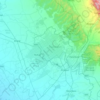
Nome: Mapa topográfico Chandigarh, altitude, relevo.
Local: Chandigarh, 160018, India (30.57344 76.61971 30.89344 76.93971)
Altitude média: 378 m
Altitude mínima: 276 m
Altitude máxima: 1.651 m