
Faça uma doação
Mapa topográfico Chatanika
Clique no mapa para exibir a altitude.
Faça uma doação
Chatanika
Located 2 miles (3.2 km) east of the confluence of Cleary Creek and the Chatanika River, Chatanika lies 20 miles (32 km) northeast of Fairbanks. Its altitude is 896 feet (273 m).
Faça uma doação
Sobre este mapa
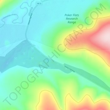
Nome: Mapa topográfico Chatanika, altitude, relevo.
Local: Chatanika, Fairbanks North Star, Alaska, United States (65.09125 -147.49933 65.13125 -147.45933)
Altitude média: 272 m
Altitude mínima: 187 m
Altitude máxima: 502 m
Faça uma doação
Outros mapas topográficos
Clique em um mapa para visualizar sua topografia, sua altitude e seu relevo.
Fairbanks
United States > Alaska > Fairbanks North Star
Fairbanks is situated within the central Tanana Valley, characterized by a diverse and dynamic topography. The city straddles the Chena River, which flows southwest into the larger Tanana River, defining Fairbanks' southern border. To the north, a gradual incline leads into a chain of hills that ascend toward…
Altitude média: 146 m
Faça uma doação