
Obrigado por apoiar este site ❤️
Faça uma doação
Faça uma doação
Mapa topográfico Mount Apo
Clique no mapa para exibir a altitude.
Obrigado por apoiar este site ❤️
Faça uma doação
Faça uma doação
Mount Apo
Mount Apo is the highest mountain peak in the Philippines, with an elevation of 2,954 meters (9,692 ft) above sea level. A large solfataric, dormant stratovolcano, it is part of the Apo-Talomo Mountain Range of Mindanao island. Apo is situated on the tripartite border of Davao City, Davao del Sur, and Cotabato; its peak is visible from Davao City 45 kilometers (28 mi) to the northeast, Digos 25 kilometers (16 mi) to the southeast, and Bansalan 20 kilometers (12 mi) to the west. Apo is a protected area and is the centerpiece of Mount Apo Natural Park.
Obrigado por apoiar este site ❤️
Faça uma doação
Faça uma doação
Sobre este mapa
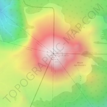
Nome: Mapa topográfico Mount Apo, altitude, relevo.
Altitude média: 2.419 m
Altitude mínima: 1.815 m
Altitude máxima: 2.931 m
Obrigado por apoiar este site ❤️
Faça uma doação
Faça uma doação