
Mapa topográfico Coombe Hill
Mapa interativo
Clique no mapa para exibir a altitude.
Sobre este mapa
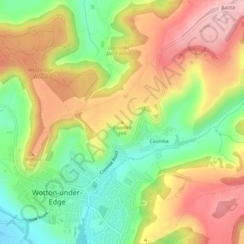
Nome: Mapa topográfico Coombe Hill, altitude, relevo.
Altitude média: 149 m
Altitude mínima: 51 m
Altitude máxima: 247 m
Outros mapas topográficos
Clique em um mapa para visualizar sua topografia, sua altitude e seu relevo.
Sharpness
United Kingdom > England > Gloucestershire > Stroud
Sharpness, Stroud, Gloucestershire, England, GL13 9PE, United Kingdom
Altitude média: 17 m
Hardwicke Green
United Kingdom > England > Gloucestershire > Stroud > Hardwicke
Hardwicke Green, Hardwicke, Stroud, Gloucestershire, England, GL2 4OD, United Kingdom
Altitude média: 21 m
Whitminster
United Kingdom > England > Gloucestershire > Stroud > Whitminster
Whitminster, Stroud, Gloucestershire, England, GL2 7PT, United Kingdom
Altitude média: 21 m