
Faça uma doação
Mapa topográfico Bee Cave
Clique no mapa para exibir a altitude.
Faça uma doação
Bee Cave
According to the United States Census Bureau in 2010, the city has a total area of 2.6 square miles (6.7 km2), all of it land. Prior to the 2010 census, Bee Cave went from being a village to being a city, increasing its area to 6.8 square miles (18 km2), all land. It borders Lakeway to the northwest. The landscape of Bee Cave is generally hilly, with elevations ranging from 875 to 1,025 ft (267 to 312 m) above sea level.
Faça uma doação
Sobre este mapa
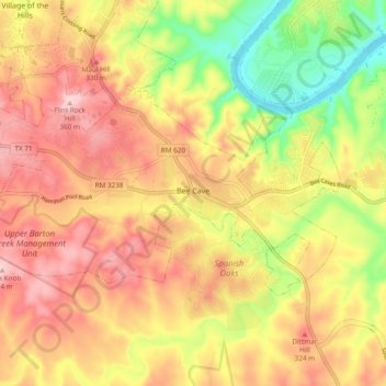
Nome: Mapa topográfico Bee Cave, altitude, relevo.
Local: Bee Cave, Travis County, Texas, United States (30.28614 -98.00369 30.32981 -97.90868)
Altitude média: 270 m
Altitude mínima: 148 m
Altitude máxima: 363 m
Faça uma doação
Outros mapas topográficos
Clique em um mapa para visualizar sua topografia, sua altitude e seu relevo.
Roy G. Guerrero Colorado River Metro Park
United States > Texas > Travis County > Austin
Altitude média: 141 m
Faça uma doação
Faça uma doação
Austin
United States > Texas > Travis County > Austin
The elevation of Austin varies from 425 feet (130 m) to approximately 1,000 feet (305 m) above sea level. Due to the fact it straddles the Balcones Fault, much of the eastern part of the city is flat, with heavy clay and loam soils, whereas the western part and western suburbs consist of rolling hills on the…
Altitude média: 203 m
Faça uma doação
Faça uma doação
Faça uma doação
Pflugerville
United States > Texas > Travis County > Pflugerville > Pflugerville
Altitude média: 219 m