
Mapa topográfico Mahikeng
Mapa interativo
Clique no mapa para exibir a altitude.
Sobre este mapa
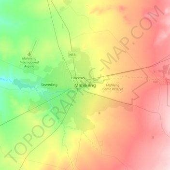
Nome: Mapa topográfico Mahikeng, altitude, relevo.
Altitude média: 1.321 m
Altitude mínima: 1.208 m
Altitude máxima: 1.452 m
Close to South Africa's border with Botswana, Mafikeng is 1,400 km (870 mi) northeast of Cape Town and 260 km (160 mi) west of Johannesburg. In 2001 it had a population of 49,300. In 2007 Mafikeng was reported to have a population of 250,000, of which the CBD constituted between 69,000 and 75,000. It is built on the open veld at an elevation of 1,500 m (4,921 ft), by the banks of the Upper Molopo River. The Madibi goldfields are some 15 km (9.3 mi) south of the town.
Outros mapas topográficos
Clique em um mapa para visualizar sua topografia, sua altitude e seu relevo.
Ramotshere Moiloa Local Municipality
South Africa > North West > Ngaka Modiri Molema District Municipality
Ramotshere Moiloa Local Municipality, Ngaka Modiri Molema District Municipality, North West, South Africa
Altitude média: 1.169 m
Libertas
South Africa > North West > Ngaka Modiri Molema District Municipality > Mahikeng Local Municipality
Libertas, Mahikeng Local Municipality, Ngaka Modiri Molema District Municipality, North West, 2745, South Africa
Altitude média: 1.285 m
Lotlamoreng Dam
South Africa > North West > Ngaka Modiri Molema District Municipality > Mahikeng Local Municipality > Seweding
Lotlamoreng Dam, Mahikeng Ward 14, Seweding, Mahikeng Local Municipality, Ngaka Modiri Molema District Municipality, North West, South Africa
Altitude média: 1.256 m
Ramotshere Moiloa Ward 17
South Africa > North West > Ngaka Modiri Molema District Municipality > Ramotshere Moiloa Local Municipality
Ramotshere Moiloa Ward 17, Ramotshere Moiloa Local Municipality, Ngaka Modiri Molema District Municipality, North West, 2850, South Africa
Altitude média: 1.188 m