
Faça uma doação
Mapa topográfico Zepp
Clique no mapa para exibir a altitude.
Faça uma doação
Sobre este mapa
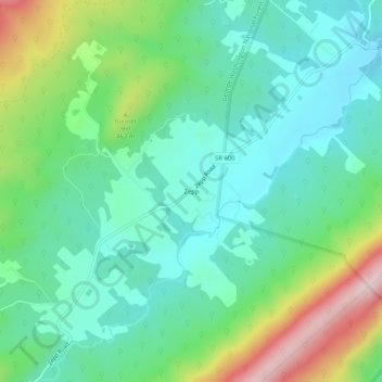
Nome: Mapa topográfico Zepp, altitude, relevo.
Local: Zepp, Shenandoah County, Virginia, United States (38.98677 -78.51779 39.02677 -78.47779)
Altitude média: 383 m
Altitude mínima: 280 m
Altitude máxima: 641 m
Faça uma doação
Outros mapas topográficos
Clique em um mapa para visualizar sua topografia, sua altitude e seu relevo.
Strasburg
United States > Virginia > Shenandoah County
According to the United States Census Bureau, the town has a total area of 3.2 square miles (8.2 km2), of which, 3.2 square miles (8.2 km2) of it is land and 0.04 square miles (0.1 km2) of it (0.63%) is water. The elevation of the area is 578 ft (176 m).
Altitude média: 195 m
Faça uma doação
Faça uma doação
Strasburg
United States > Virginia > Shenandoah County
According to the United States Census Bureau, the town has a total area of 3.2 square miles (8.2 km2), of which, 3.2 square miles (8.2 km2) of it is land and 0.04 square miles (0.1 km2) of it (0.63%) is water. The elevation of the area is 578 ft (176 m).
Altitude média: 195 m