
Faça uma doação
Mapa topográfico Cozumel
Clique no mapa para exibir a altitude.
Faça uma doação
Cozumel
Large parts of the island are covered with mangrove forest which has many endemic animal species. Cozumel is a flat island based on limestone, resulting in a karst topography. The highest natural point on the island is less than 15 m (49 ft) above sea level. The cenotes are deep water-filled sinkholes formed by water percolating through the soft limestone soil for thousands of years. Cozumel's cenotes are restricted to qualified cave divers with appropriate credentials.
Faça uma doação
Sobre este mapa
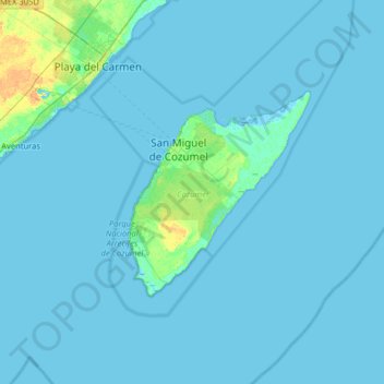
Nome: Mapa topográfico Cozumel, altitude, relevo.
Local: Cozumel, Quintana Roo, Mexico (20.27159 -87.36343 20.59771 -86.72395)
Altitude média: 1 m
Altitude mínima: -3 m
Altitude máxima: 20 m
Faça uma doação
Outros mapas topográficos
Clique em um mapa para visualizar sua topografia, sua altitude e seu relevo.
Faça uma doação
Presidente Juárez
Mexico > Quintana Roo > Felipe Carrillo Puerto > Presidente Juárez
Altitude média: 23 m