
Mapa topográfico Kings Peak
Mapa interativo
Clique no mapa para exibir a altitude.
Sobre este mapa
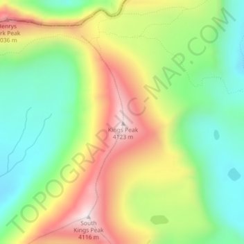
Nome: Mapa topográfico Kings Peak, altitude, relevo.
Local: Kings Peak, Duchesne County, Utah, United States (40.77619 -110.37285 40.77629 -110.37275)
Altitude média: 3.743 m
Altitude mínima: 3.469 m
Altitude máxima: 4.118 m
Kings Peak is the highest peak in the U.S. state of Utah, with an elevation of 13,528 feet (4,123 m) NAVD 88.
Outros mapas topográficos
Clique em um mapa para visualizar sua topografia, sua altitude e seu relevo.
Fruitland
United States > Utah > Duchesne County
Fruitland, Duchesne County, Utah, 84027, United States
Altitude média: 2.028 m
Starvation State Park
United States > Utah > Duchesne County
Starvation State Park, Duchesne County, Utah, United States
Altitude média: 1.786 m
Roosevelt
United States > Utah > Duchesne County
Roosevelt, Duchesne County, Utah, 84066, United States
Altitude média: 1.553 m
High Uintas Wilderness
United States > Utah > Duchesne County
High Uintas Wilderness, Duchesne County, Utah, United States
Altitude média: 2.919 m