
Obrigado por apoiar este site ❤️
Faça uma doação
Faça uma doação
Mapa topográfico Puerto Carreño
Clique no mapa para exibir a altitude.
Obrigado por apoiar este site ❤️
Faça uma doação
Faça uma doação
Puerto Carreño
The area of the municipality is within the llanos plains which cover large areas in Colombia and Venezuela that are rich in biodiversity. Geologically the municipality of Puerto Carreño lies on the Guiana Shield mostly made up by Cenozoic and Precambric formations, with some low altitude mountains such as the Mounts of Casuarito and the Hormiga and Guaripa mountains.
Obrigado por apoiar este site ❤️
Faça uma doação
Faça uma doação
Sobre este mapa
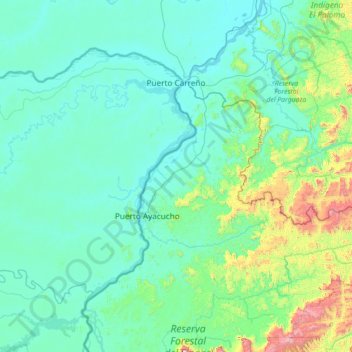
Nome: Mapa topográfico Puerto Carreño, altitude, relevo.
Local: Puerto Carreño, Vichada, RAP Llanos, Colombia (5.30179 -68.82483 6.32878 -67.40844)
Altitude média: 194 m
Altitude mínima: 32 m
Altitude máxima: 1.599 m
Obrigado por apoiar este site ❤️
Faça uma doação
Faça uma doação
Outros mapas topográficos
Clique em um mapa para visualizar sua topografia, sua altitude e seu relevo.