
Mapa topográfico Dobrogea
Mapa interativo
Clique no mapa para exibir a altitude.
Dobrogea
Except for the Danube Delta, a marshy region located in its northeastern corner, Dobruja is hilly, with an average altitude of about 200–300 metres. The highest point is the Țuțuiatu (Greci) Peak in the Măcin Mountains, having a height of 467 m. The Dobruja Plateau covers most of the Romanian part of Dobruja. The Ludogorie Plateau is found in Bulgaria. Lake Razelm is one of the most important lakes in Northern Dobruja.
Sobre este mapa
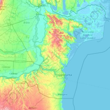
Nome: Mapa topográfico Dobrogea, altitude, relevo.
Local: Dobrogea, Grădina, Constanța, 907277, Romania (43.52455 27.39217 45.52455 29.39217)
Altitude média: 53 m
Altitude mínima: -4 m
Altitude máxima: 478 m