
Mapa topográfico Kühlenfels
Mapa interativo
Clique no mapa para exibir a altitude.
Sobre este mapa
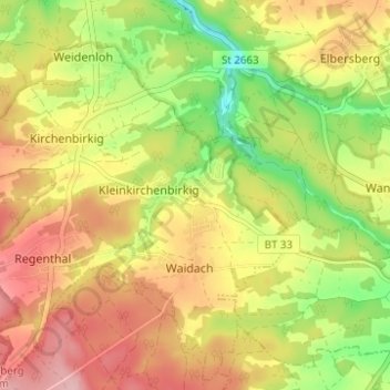
Nome: Mapa topográfico Kühlenfels, altitude, relevo.
Altitude média: 463 m
Altitude mínima: 382 m
Altitude máxima: 534 m
Altenhof | Arnleithen | Elbersberg | Geusmanns | Graisch | Haselbrunn | Haßlach | Hohenmirsberg | Kirchenbirkig | Kleinkirchenbirkig | Kleinlesau | Kühlenfels | Leienfels | Mandlau | Mittelmühle | Neu-Geusmanns | Pottenstein | Prüllsbirkig | Pullendorf | Püttlach | Rackersberg | Regenthal | Rupprechtshöhe | Schüttersmühle | Siegmannsbrunn | Soranger | Steifling | Trägweis | Tüchersfeld | Vorderkleebach | Waidach | Wannberg | Weidenhüll bei Elbersberg | Weidenhüll bei Leienfels | Weidenloh | Weidmannsgesees
Outros mapas topográficos
Clique em um mapa para visualizar sua topografia, sua altitude e seu relevo.
Püttlach
Deutschland > Bayern > Landkreis Bayreuth > Pottenstein
Püttlach, Pottenstein, Landkreis Bayreuth, Bayern, 91278, Deutschland
Altitude média: 429 m