
Mapa topográfico Powell
Clique no mapa para exibir a altitude.
Sobre este mapa
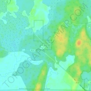
Nome: Mapa topográfico Powell, altitude, relevo.
Altitude média: 487 m
Altitude mínima: 478 m
Altitude máxima: 505 m
Outros mapas topográficos
Clique em um mapa para visualizar sua topografia, sua altitude e seu relevo.
Hurley
United States > Wisconsin > Iron County
Hurley was at the center of a boundary dispute between Michigan and Wisconsin, culminating in a United States Supreme Court case in 1926, confirming Hurley belonging to Wisconsin. The Montreal River was mapped in detail in 1841 by Lieutenant Thomas Jefferson Cram of the United States Land Office Department of…
Altitude média: 455 m
Manitowish River
United States > Wisconsin > Iron County > Town of Mercer > Manitowish
Altitude média: 486 m