
Mapa topográfico Kilkenny
Clique no mapa para exibir a altitude.
Kilkenny
Kilkenny is situated in the Nore Valley on both banks of the River Nore, at the centre of County Kilkenny in the province of Leinster in the south-east of Ireland. It is 117 kilometres (73 mi) away the capital Dublin and 48 kilometres (30 mi) north from the nearest city Waterford. Wexford is 80 kilometres (50 mi) to the south-east and Limerick is 122 kilometres (76 mi) to the west. The elevation is 60 metres (200 ft) above mean sea level. The area of Kilkenny borough is 3.74 square kilometres (1.44 sq mi). The first edition of the Ordnance Survey map for Kilkenny was in 1837 and is held by the County Library.
Sobre este mapa
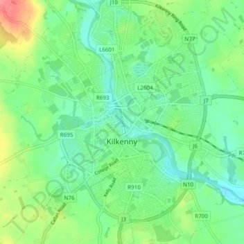
Nome: Mapa topográfico Kilkenny, altitude, relevo.
Altitude média: 61 m
Altitude mínima: 37 m
Altitude máxima: 114 m
Outros mapas topográficos
Clique em um mapa para visualizar sua topografia, sua altitude e seu relevo.
Brandon Hill
Brandon Hill (Irish: Cnoc Bhréanail) is the highest mountain in County Kilkenny, Ireland, with an elevation of 515 m (1,690 ft) and prominence at 448 m (1,470 ft). The South Leinster Way, a long-distance trail, meandering through the Barrow Valley and traverses Brandon Hill. The village of Graiguenamanagh and…
Altitude média: 294 m