
Mapa topográfico Coupar Angus
Mapa interativo
Clique no mapa para exibir a altitude.
Sobre este mapa
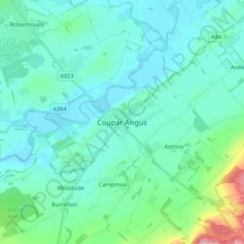
Nome: Mapa topográfico Coupar Angus, altitude, relevo.
Altitude média: 70 m
Altitude mínima: 30 m
Altitude máxima: 298 m
Outros mapas topográficos
Clique em um mapa para visualizar sua topografia, sua altitude e seu relevo.
Blacklunans
United Kingdom > Scotland > Perth and Kinross
Blacklunans, Perth and Kinross, Scotland, PH10 7LL, United Kingdom
Altitude média: 357 m
Perth
United Kingdom > Scotland > Perth and Kinross
Perth, Perth and Kinross, Scotland, PH1 5SU, United Kingdom
Altitude média: 131 m
Crieff
United Kingdom > Scotland > Perth and Kinross
Crieff, Perth and Kinross, Scotland, PH7 3BS, United Kingdom
Altitude média: 115 m
Forgandenny
United Kingdom > Scotland > Perth and Kinross
Forgandenny, Perth and Kinross, Scotland, PH2 9EQ, United Kingdom
Altitude média: 53 m
Blairgowrie and Rattray
United Kingdom > Scotland > Perth and Kinross > Blairgowrie and Rattray
Blairgowrie and Rattray, Perth and Kinross, Scotland, PH10 6AB, United Kingdom
Altitude média: 121 m
Kindallachan
United Kingdom > Scotland > Perth and Kinross
Kindallachan, Perth and Kinross, Scotland, PH9 0NW, United Kingdom
Altitude média: 162 m