
Mapa topográfico Dahl
Clique no mapa para exibir a altitude.
Dahl
Dahl liegt südöstlich der Kernstadt Paderborn auf der Paderborner Hochfläche am Westrand des Eggegebirges auf einer Höhe von 218 m ü. NN. Durch das Dorf fließt der Ellerbach.
Sobre este mapa
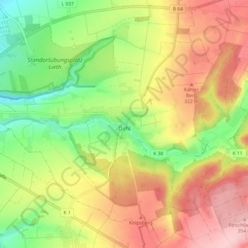
Nome: Mapa topográfico Dahl, altitude, relevo.
Altitude média: 272 m
Altitude mínima: 183 m
Altitude máxima: 363 m
Outros mapas topográficos
Clique em um mapa para visualizar sua topografia, sua altitude e seu relevo.
Habichtsee
Deutschland > Nordrhein-Westfalen > Kreis Paderborn > Paderborn > Sennelager
Altitude média: 112 m
Barkhausen
Deutschland > Nordrhein-Westfalen > Kreis Paderborn > Paderborn > Wewer
Altitude média: 139 m
Tallesee Mittelsee
Deutschland > Nordrhein-Westfalen > Kreis Paderborn > Paderborn
Altitude média: 118 m
Nesthauser See
Deutschland > Nordrhein-Westfalen > Kreis Paderborn > Paderborn > Sande
Altitude média: 101 m