
Mapa topográfico Mount Barr
Clique no mapa para exibir a altitude.
Mount Barr
Mount Barr is a mountain in the Skagit Range of the Cascade Mountains of southern British Columbia, Canada, located on the northeast side of Wahleach Lake and just southwest of Hope. It is a ridge highpoint with an elevation of 1,907 m (6,257 ft).
Sobre este mapa
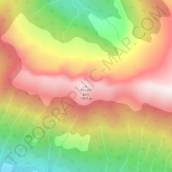
Nome: Mapa topográfico Mount Barr, altitude, relevo.
Altitude média: 1.414 m
Altitude mínima: 812 m
Altitude máxima: 1.924 m
Outros mapas topográficos
Clique em um mapa para visualizar sua topografia, sua altitude e seu relevo.
Jones Lake
Canada > British Columbia > Fraser Valley Regional District > Area D (Popkum/Bridal Falls/Wahleach)
Altitude média: 956 m