
Mapa topográfico Truckee
Clique no mapa para exibir a altitude.
Truckee
Truckee is characterized by its dramatic topography set in the Sierra Nevada mountain range. The town sits at an elevation of approximately 5,817 feet (1,774 meters), surrounded by a stunning landscape of rugged mountains, rolling hills, and expansive forested areas. Prominent features include Donner Pass, which is a significant historical and geographical landmark, and Donner Lake, a picturesque body of water nestled among the peaks. The terrain is diverse, offering steep slopes and high-altitude trails, which are popular for hiking, biking, and skiing, particularly in winter when the region is blanketed in snow. The unique combination of elevation and natural beauty makes Truckee a prime location for outdoor enthusiasts and those seeking scenic vistas year-round.
Sobre este mapa
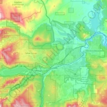
Nome: Mapa topográfico Truckee, altitude, relevo.
Local: Truckee, Nevada County, California, United States (39.31616 -120.30158 39.38733 -120.07728)
Altitude média: 1.919 m
Altitude mínima: 1.662 m
Altitude máxima: 2.494 m
Outros mapas topográficos
Clique em um mapa para visualizar sua topografia, sua altitude e seu relevo.
Nevada County Fairgrounds
United States > California > Nevada County > Grass Valley > Boston Ravine
Altitude média: 743 m
Empire Mine State Historic Park
United States > California > Nevada County > Grass Valley > Boston Ravine
Altitude média: 795 m