
Obrigado por apoiar este site ❤️
Faça uma doação
Faça uma doação
Mapa topográfico Nanga Parbat
Clique no mapa para exibir a altitude.
Obrigado por apoiar este site ❤️
Faça uma doação
Faça uma doação
Nanga Parbat
To the south, Nanga Parbat has what is often referred to as the highest mountain face in the world: the Rupal Face rises 4,600 m (15,090 ft) above its base. To the north, the complex, somewhat more gently-sloped Rakhiot Flank rises 7,000 m (23,000 ft) from the Indus River valley to the summit in just 25 km (16 mi), one of the ten greatest elevation gains in such a short distance on Earth.
Obrigado por apoiar este site ❤️
Faça uma doação
Faça uma doação
Sobre este mapa
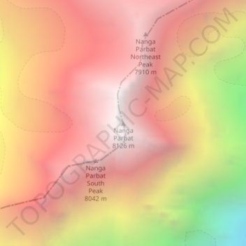
Nome: Mapa topográfico Nanga Parbat, altitude, relevo.
Altitude média: 7.086 m
Altitude mínima: 5.181 m
Altitude máxima: 8.104 m
Obrigado por apoiar este site ❤️
Faça uma doação
Faça uma doação
Outros mapas topográficos
Clique em um mapa para visualizar sua topografia, sua altitude e seu relevo.