
Faça uma doação
Mapa topográfico Silkstone
Clique no mapa para exibir a altitude.
Faça uma doação
Sobre este mapa
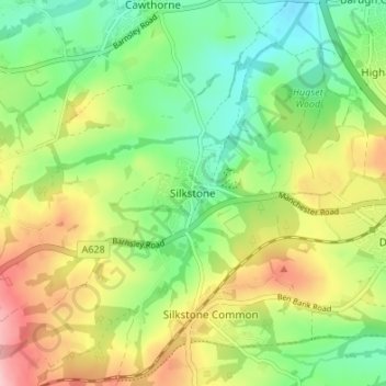
Nome: Mapa topográfico Silkstone, altitude, relevo.
Altitude média: 134 m
Altitude mínima: 68 m
Altitude máxima: 230 m
Faça uma doação
Outros mapas topográficos
Clique em um mapa para visualizar sua topografia, sua altitude e seu relevo.
Faça uma doação
Shafton
United Kingdom > England > Barnsley
Shafton lies to the north of Shafton Two Gates, on the road to Ryhill. It is located at approximately 53° 35' 10" North, 1° 24' West, at an elevation of around 262 feet (80 m) above sea level. Sceptun in the Domesday Book of 1086 then later in c. 1160 Scaftona meaning a farmstead marked by a pole, or made…
Altitude média: 65 m
Faça uma doação
High Hoyland
United Kingdom > England > Barnsley
High Hoyland is a village and civil parish in the Metropolitan Borough of Barnsley in South Yorkshire, England, on the border with West Yorkshire. It lies to the west of Kexbrough, and is located at approximately 53°35′10″N 1°35′30″W / 53.58611°N 1.59167°W / 53.58611; -1.59167, at an…
Altitude média: 139 m